Monday Maps and Diagrams 11/26/18
In my informal Monday Maps and Diagrams series I will showcase scans of SF maps and diagrams from my personal collection. As a kid I was primarily a fantasy reader and I judged books on the quality of their maps. When my reading interests shifted to science fiction, for years I still excitedly peeked at the first few pages… there could be a map!
Let’s start off with a simple yet effective map via Jack Vance. Islands, and rivers, and swamps….
The Map:
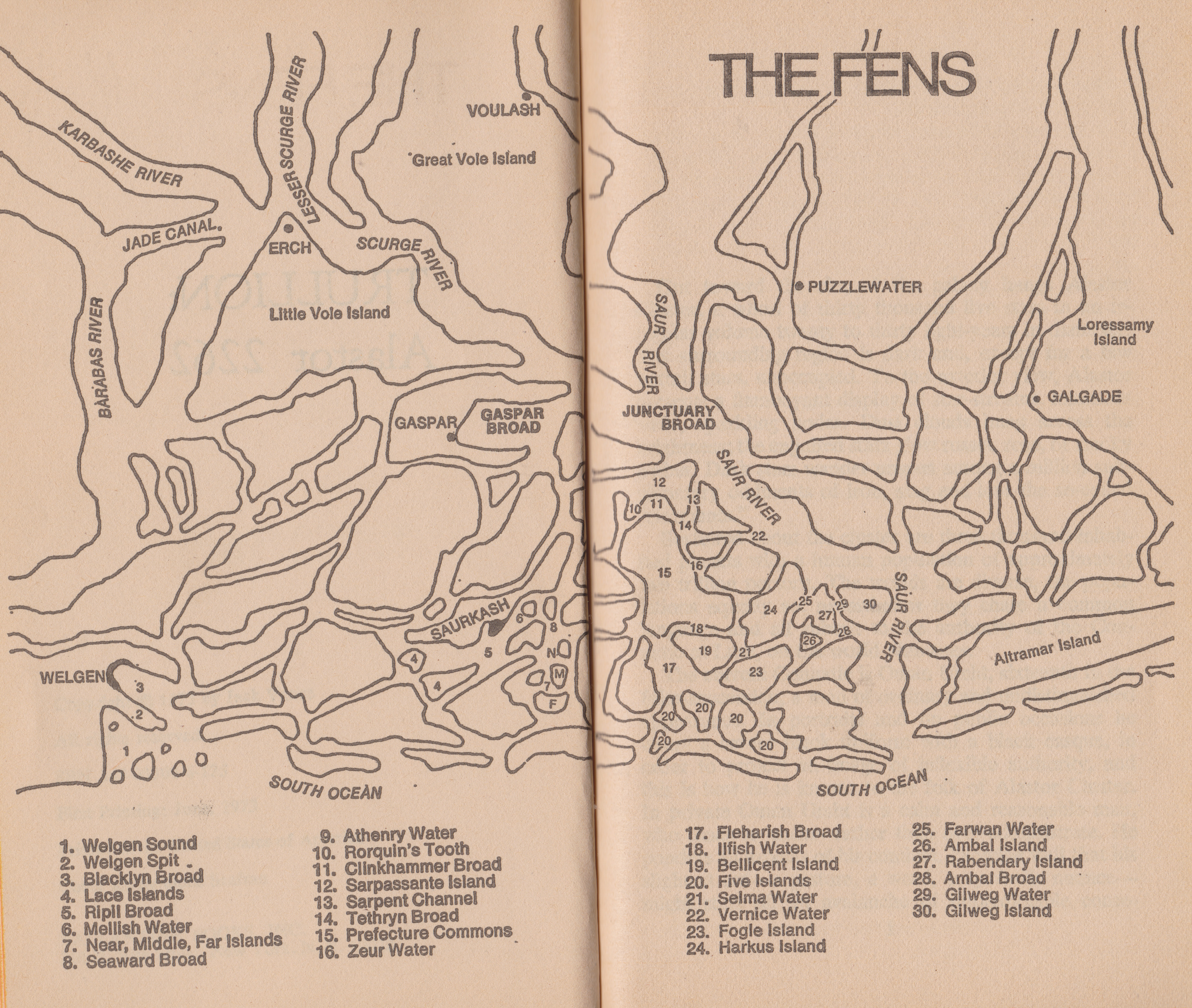
Citation: Map from the 1973 Ballantine edition of Jack Vance‘s Trullion: Alastor 2262 (1973) [click to enlarge].
Related Links:
Monday Maps and Diagrams 2/22/21: Cordwainer Smith’s Instrumentality of Mankind Timeline
Monday Maps and Diagrams 7/25/19: Greg Bear’s Hegira (1979)
Monday Maps and Diagrams 2/18/19: David Brin’s Sundiver (1980)
Monday Maps and Diagrams 1/21/19: Larry Niven’s The Integral Trees (1984)
Monday Maps and Diagrams 1/14/19: Alan Dean Foster’s Voyage to the City of the Dead (1984)
Monday Maps and Diagrams 12/24/18: C. J. Cherryh’s Forty Thousand in Gehenna (1983)
Monday Maps and Diagrams 12/17/18: Russell Hoban’s Riddley Walker (1980)
Monday Maps and Diagrams 12/10/18: Suzy McKee Charnas’ Walk to the End of the World (1974)
Monday Maps and Diagrams 11/26/18: Mark S. Geston’s The Lords of the Starship (1967)
Monday Maps and Diagrams 12/3/18: Jack Vance’s Trullion: Alastor 2262 (1973)
For a more detailed article on the visual and graphic elements of SF consult Charts, Diagrams, and Tables in Science Fiction.
For book reviews consult the INDEX
For cover art posts consult the INDEX
For additional articles consult the INDEX

I do love maps – especially fictional ones! I still have my copy of a lovely book I was given more years ago than I care to acknowledge, “An Atlas of Fantasy” – marvellous volume!
I’d love to see your favorite map from that Atlas!
I’ll have to dig it out – maybe I’ll do a little post on it… 😉
All maps are, in fact, fictional. They take account of a territory by means of sign and reference. The distance between map and territory mapped (and the mapping territory––the map-maker!) is a zone of abstraction. The actuality of territory (and, of course, we could also claim that the territory can be read as a map––a different sort of map that refers to a different territory altogether) is not present on the map’s surface. Instead, we find a fictional account––its an invention of an displaced territory in that it is an interpretation that feigns to be the territory. Well… I love maps too!
Leaking Borges on me….
I bought this edition not long after it came out and I remember studying the map, and referring to it as I read the book. It bacame one of several favourites of his that I have and I’ve re-read it more than once since.
It does seem to me that, even without the deeper knowledge of the plot that re-reading gives, that a map really isn’t that important for anyone to enjoy this book! It’s set in an area of myriad small islands and dividing waterways and that’s about all you need to know! Knowing their exact relationship to each other is, at best, minorly useful, although I’ve no doubt it was a big help to the author as he wrote the book.
I’ve noticed this about the many Jack Vance books I have in my collection with maps that I’ve scanned for this series — spoilers (haha, not really, just a later installment in this series) — > the map in Vance’s Emphyrio adds virtually nothing to the story… It’s so general, almost pathetically lame, and so many important locations are not even on the map. I want the map to add something to the story, to add complexity, to add small details that add to the depth of the reading experience. And you’re right, this one probably doesn’t…. But the map in Wolf’s Killerbowl (1975), which inspired this series, certainly does (the playing field in Boston).
I remember drawing my own map of Vance’s Dying Earth when I was a teenager back before he had witten more than The Eyes of the Overworld. When, after many years and three more books, an ‘official’ map was created, I was surprised at some of the major differences between his description of the geography (which he obviously knew!) and my interpretation of the info given in the text.
My map may have been closer to the truth if I had waited until more books with more details were published, but I suppose it demonstrated that I could find the book/s enjoyable even with a wrong interpretation of some of the basic geography!
The maps in Emphyrio & Showboat World aren’t very useful, the one in T’schai somewhat useful but rather rudimentary and usually printed across th book’s gutter, and Durdane (which could maybe have benefited from one) didn’t have one for years although I think the VIE project came up with one eventually.
I’d say his maps generally give the appearance of being an aide memoire for his writing, which he’s been persuaded to allow to be included in the books!
Do you know if the “official” Dying Earth map is online? There was no map in my edition.
I poked around a little and found quite a lot of Dying Earth maps, but not the simple line drawing one I knew first. It’s odd how the world has been perceived over the years; the early line drawn map definitely showed the Songan Sea as surounded by land (mainly desert) with, I think, one main river flowing in. Later fan-created maps show the Songan Sea as a gulf of a much larger ocean.
The Underwood Miller maps in at least one of their titles shows it as closed off, so the change has happened since then. If I don’t see an official map, I’ll put up a version or two from the books I have. The early maps show Cugel’s initial destination when exiled as to the north (as in the book) but newer ones I’ve looked at seem to have him being transported more to the North East…
I had assumed that once a relatively official map had been published (by U/M or earlier) that the basics would remain the same but that appears not to be the case!
One of the other maps I have scheduled to post is from a later 90s edition Orb edition of Vance’s Planet of Adventure books (City of the Chasch, Servants of the Wankh, The Dirdir, The Pnume). It has a much more snazzy and refined map than the line drawings most of the early DAW editions had….
I suspect the same process occurred with Dying Earth. Which edition of The Dying Earth had a map first? Not mine — 1979 mass market Pocket Books edition….
Hi
An interesting idea for a series. I have to admit I rarely refers to the maps after an initial scan. But I think they do help with the sense of world building in fantasy and science fiction works. Maps like the occasional appendices, which seem to occur more in fantasy novels, can also provide more of an insight into the author’s thought processes and deepen the story for the reader.
Guy
Yeah, the maps I found are definitely more in the pseudo-medieval far future type SF books I own….
If you encounter one I should include in the series, let me know. I might not own a copy but I could buy it for the series if its something I’d read.
Pingback: Mapping the imaginary – gratuitous book pics and #utopia again! | Kaggsy's Bookish Ramblings
When I think of fantasy maps, Robert Jordan’s books come to mind; maybe I’m mistaken (not having finished the series yet… they became such a slog by about book 8), but it seems that, as the series wore on, the smaller maps (which would provide a more detailed grid of a city/village) were less frequent (again, still have a couple books to go).
I also enjoyed the first 7 or so books when I was in my late teens — and the maps… I have no desire to return to the series and certainly won’t read the posthumous concluding volumes written by Sanderson. I’ve long since moved away from epic/long series SF/F.